Dynamic Topography of the Black Sea fromTopex/Poseidon and ERS
Altimetry
Altimeter measurements provide excellent possibility for monitoring of mesoscale circulation of oceanic basins. Application of altimeter data to inland seas is a special issue as spatial and temporal scales of phenomenon is quite different.
The Black Sea is a convenient basin in which to apply altimeter measurements to investigate the circulation. The basin has a simple coastline without large gulfs or islands. The only peninsula is the Crimea, which divides the sea in two almost symmetric parts, excluding the northwestern shallow shelf.
A three-dimensional regular gridded monthly hydrographic climatology has been prepared using these data (Altman et al. 1987). Basin-wide hydrographic surveys from the co-operative field program COMSBlack (Oguz,Malanotte-Rizzoli, and Aubrey 1995) overlap in time with the ERS and TOPEX/POSEIDON (T/P) missions and are available for accurate evaluation of the dynamic topography retrieved from altimetry.
An approach of the joint use of altimeter measurements and climatological hydrography for the dynamic topography is developed by the group of specialists of Marine Hydrophysical Institute of National Ukrainian Academy of Sciences and Ocean and Ice Branch of Goddard Space Flight Center of NASA.
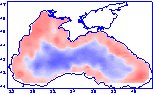
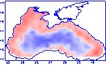
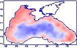
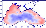
Regularly mapped dynamical topography of the Black Sea are prepared based on the data of NASA Ocean Altimeter Pathfinder Project at Goddard Space Flight Center, Versions 1.0, and 2.0 of the product were prepared using ERS and T/P altimeter data for 1992-1994, 1992-1997. Algorithm of altimeter data processing has been presented in (Korotaev et al., 1997,Korotaev et al., 1999).
|
|
|
|
|
|
Versions 1.1, 2.1 and 3.0 use slightly different algorithm with more careful preliminary correction of the data. Version 3.0 is based on data from ERS-1, ERS-2 and T/P altimetry obtained from April 1992 till November 1999. From hydrographic surveys carried out within the framework of the CoMSBlack program are used for the validation of the dynamic topography derived from altimetry.
| Download presentation
PowerPoint 97 (7562K) |
|
|
|
|