R/V BILIM LEG-3 Cruise
Duration of the cruise: 03 Oct.-24 Oct. 1999
As part of the September-October 1999 R/V Bilim Cruise, a 21-day long
survey in the Black Sea, Marmara Sea, Aegean Sea and the Mediterranean Sea carried out
during October 3-24, 1999. This survey aimed to develop regional algorithm for SeaWiFS
sensor, obtain optical properties for Turkish Seas and comparison of the ecosystem of the
four seas which have different characteristics. |
 |
 |
The specific objectives were:
 |
To conduct a mesoscale survey to determine bio-optical
properties of the seas around Turkey |
|
To collect nutrient, chlorophyll, and light profile data to
characterize basic state of the ecosystem |
|
To measure optical variables such as: light transparency,
irradiance and absorption coefficient of water at PAR; |
|
To collect biological data that effects optical properties
of the sea. |
|
To collect data on the atmospheric transparency to perform
atmospheric correction of SeaWiFS data. |
|
Stations visited during LEG-3
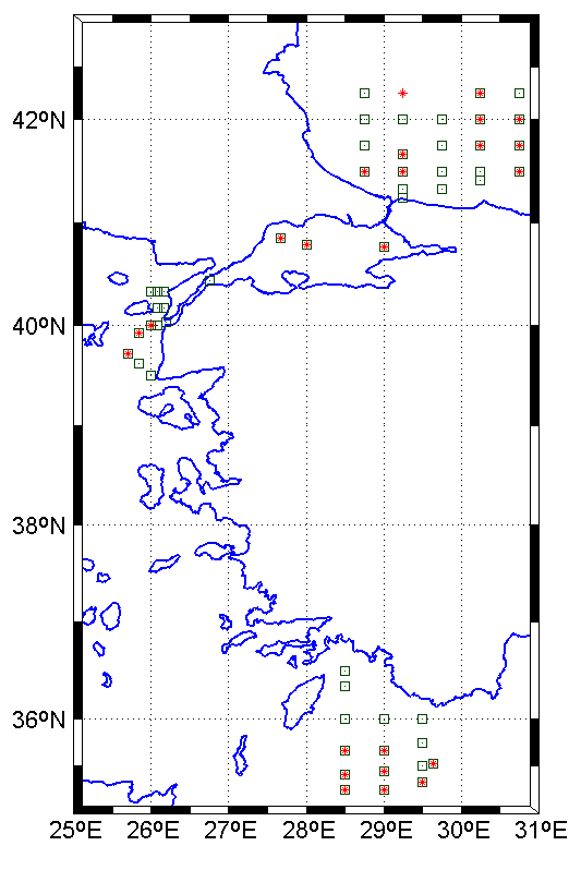
 |
standard oceanographic stations |
 |
stations with optical measurements |
This cruise was performed with participation of the 3 groups: Institute of Marine
Sciences of Middle East Technical University(IMS-METU), Marine Hydrophysical Institute
(MHI)-Sevastopol and Scripps Institution of Oceanography (SIO). MHI and SIO scientists
made atmospheric and oceanic optical measurement while the other measurements were done by
IMS-METU group.
The work was a combination of station and underway activities. During the
cruise 53 oceanographic stations (25 optic) visited; Black Sea 23 (10 optic), Marmara Sea
3, Aegean 12 (3 optic), Mediterranean 15 (8 optic). The along track work consisted of
acoustic measurements of the volume backscatter of the plankton throughout the water
column and atmospheric transparency and water surface reflectance. The ship’s ADCP
unit was used to make continuos measurements of the water current profile under the ship.
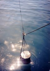
The CTD data obtained using SBE 11plus also equipped with fluorometer and
transmissivity sensors. The fluorometer readings were calibrated with spectrofluorometric
measurements of the Chlorophyll-a. Rosette with niskin bottles were used in conjuction
with the CTD to provide bottle sampling for nutrients and Chlorophyll-a. Nutrient
measurements were performed on board with Technicon Autoanalyser using standard methods.
The hull mounted 150kHz ADCP (Acoustic Doppler Current Profiler) from RD
Instruments were used to measure the current velocities while ship was cruising between
stations. Ship gyro were used to convert the velocities measured relative to the ship
coordinate to the earth referenced coordinate. Ship location at each ensemble were fixed
using Differential Global Positioning System (DGPS). Absolute current velocity
computations obtained by subtracting ship velocities calculated from DGPS fixes
The Chlorophyll-a (Chl-a) and Phaeopigments-a data were collected usually
from 3 depths; surface, sub-surface maxima and below the subsurface maxima. Phytoplanton
samples were also collected at these depths.
The following measurements were also done as a complimantary to biological
and chemical measurements done during leg 2: absorption by Phytoplankton, absorption by
Detritus, absorption by Soluble Material, Bacterial Chlorophyll-e, total suspended
sediment.
Irradiance measurements (upward and downward) are carried out by LI-1800UW
model spectroradiometer. Also LI-1000 model PARmeter was used onboard with parallel to
this measurements. LI-18000 scans were made between 300-800 nm with 1nm interval for all
25 optic stations and for the depths (with 2 meter interval) until 1% light depth. For
validation of this data air measurements are also made for both downward and upward
irradiance. Cloud and seasurface conditions (which greatly affect measurements) are noted
as well for later check on processed irradiance data.
The reflectance spectra measurements were carried out in daylight time for
sun elevation more than 20o at stations and underway using spectral radiometer
developed at MHI. The water transparency at nine narrow visible channel simultaneously
(360, 421, 444, 464, 520, 556, 606, 660, and 670 nm) were measured from surface to 5 m.
These measurements were done in parallel to reflectance measurements.
The measurement of atmospheric transparency through the measurement of the
Aerosol Optical Thichness and marine reflectance were done by R. Frouin from SIO for the
cases for which cloud cover was <0.3
Cruise materials are available here.