R/V BILIM LEG-2 Cruise
Duration of the cruise: 22 Sept.-30 Sept. 1999
 This field
work in the Black Sea was realised performing the objectives of the joint programme
between Harvard University-Department of Organismic and Evolutionary Biology/USA and
Middle East Technical University-Institute of Marine Sciences/TURKEY. The main task of
this programme is to characterise the nitrogen dynamics in order to understand what
factors are responsible for temporal and spatial patterns in the nitrogen cycle that have
bearing on the overall functioning of the Black Sea ecosystem. This joint programme
entitled as “New Production and Nitrogen Cycling in the Black Sea” supported by
NSF/USA has started on 1 January 1998 and its duration is two years. Director of the
Project is Prof. James J. McCarthy (Harvard/USA) and Co-director is Prof.Ilkay
Salihoglu (METU-IMS/TURKEY). This programme is in conjunction with the METU-IMS’s
national programme entitled as “Dynamics of the Lower Trophic Levels of the Black
Sea: Biochemical Processes and System Modeling” supported by TÜBITAK (Turkish
Scientific Research Council)/TURKEY which is long term (five years) programme started in
January 1997.
This joint research programme in the Black Sea is also scientifically relevant and parallel to the recently proposed NATO Project entitled as “The Black Sea Ecosystem Processes, Prediction and Operational Data Managements”. This Project involves the scientific research needed to lay the foundations for a permanent observations and prediction system for the Black Sea.

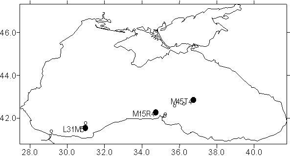
The research pertinent to the collaborative activities between Harvard University and METU-Institute of Marine Sciences started on January 1, 1998 and the third and last field work conducted aboard R/V Bilim (METU-IMS) in September 1999. The 2nd Leg started on 22 September 1999 and ended on 30 September 1999. Three long stations (one in the Sakarya canyon region, one in the western side of Sinop, in the Rim Current and one in the eastern gyre) were visited during this leg. These stations are marked with filled circles on scheme. The station(s) planned in the western Black Sea could not be visited due to the very harsh weather conditions. R/V Bilim returned to the Bosphorus and she waited for the opportunity of good weather till 3 October 1999 and then the 2nd Leg was terminated. R/V Bilim visited 6 different stations for short periods during this Leg. One extra station was performed in the western deep basin during the 3rd Leg. Location of the stations for the R/V Bilim LEG-2 Cruise

The general information on the stations (Bridge Protocol)
| Date | Arrival
Departure |
Location | Coordinates | Station* | Total Depth(m) | Air Pres. | Air Temp. | Wind Speed (knot) | Wind Direction | Notes |
| 23.09.1999-24.09.1999 | 05:55 23:30 | W.Black Sea (Off Sakarya) |
41° 31' N 30° 59' E |
L31M59 | 1450 | 1024.2 | 22 | 10 | NE | |
| 25.09.1999 | 22:50 23:09 | E.Black Sea (E. Cyclone) | 42° 33' N 35° 45' E |
M33S45 | 2000 | 1025.3 | 20 | - | - | (Only CTD) |
| 26.09.1999 | 01:30 01:52 | E.Black Sea (E. Cyclone) | 42° 39' N 36° 15' E |
M39T15 | 1850 | 1025.1 | 20 | - | - | (Only CTD) |
| 26.09.1999-27.09.1999 | 04:23 21:00 | E.Black Sea (E.Cyclone) | 42° 45' N 36° 45' E |
M45T45 | 2100 | 1025.7 | 20 | - | - | |
| 28.09.1999 | 06:45 07:02 | E. of Sinop | 42° 01' N 35° 15' E |
M01S15 | 70 | 1019.8 | 24 | 15 | SE | (Time Series) |
| 28.09.1999 | 07:40 08:10 | E. of Sinop | 42° 05.8' N 35° 13.8' E |
M05.8S13.8 | 250 | 1020 | 26 | - | - | (Time Series) |
| 28.09.1999-29.09.1999 | 10:38 00:25 | W. of Sinop | 42° 15' N 34° 45' E |
M15R45 | 400 | 1018.4 | 30 | 17 | SE | |
| 29.09.1999 | 19:08 19:16 | Off Sakarya | 41° 45' N 31° 00' E |
L45N00 | 1550 | 1014.4 | 22 | - | - | (Only N2 Fix) |
| 30.09.1999 | 04:40 08:50 | W. Black Sea | 41° 34' N 29° 12' E |
L34L12 | 650 | 1017.6 | 22 | 12 | N | (Cancelled) |
| 30.09.1999 | 08:50 08:55 | W. Black Sea | 41° 22.6' N 29° 08.75' E |
L22.6L08.75 | - | 1018.9 | 25 | 16 | N | (Only N2 Fix) |
Stations written in BOLD character are the main long stations.
Cruise materials are available here.
|