Heterotrophic Bacteria counts (at total 11 stations)
Institute of Marine Sciences, Middle East Technical University,
Turkey
uysal@ims.metu.edu.tr
|
|
Cyanobacteria (Synechococcus spp.) counts (only at four stations)
and Heterotrophic Bacteria counts (at total 11 stations) |
| Leg 2 Plots |
Institute of Marine Sciences, Middle East Technical University,
Turkey
tugrul@ims.metu.edu.tr
| Parameters pressure, temperature, salinity, sigma-t, transmiss, voltage5, nonsen, DOW, H2S, PO4, NO2+NO3, NO3, NO2, Si, NH4, Chl, Phaeopigment, Total Chl, MnAuto, FeAuto |
|
Marine Hydrophysical Institute,
Ukraine
sergey@alpha.mhi.iuf.net
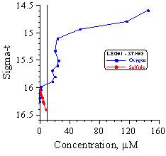 |
Hydrogen Sulfide and Oxygen |
| Leg 1 Plots | |
| Hydrogen Sulfide and Oxygen | |
| Leg 2 Plots | |
| Hydrogen Sulfide and Oxygen | |
| Data | |
| Hydrogen Sulfide and Oxygen | |
| Data |
Description of methods
(HTML format) and presentation Voltammetric
pump profiling of O2, H2S and other dissolved reduced
sulfur in the oxic/anoxic water column of the Black Sea (PowerPoint 97).
Univ. Washington, US
jmurray@u.washington.edu
Institute of Marine Sciences, Middle East Technical University,
Turkey
oguz@ims.metu.edu.tr
| CRUISE ID: K162160010035231653 | CRUISE ID: K162160010045231805 | CRUISE ID: K162160020045232156 | CRUISE ID: K162160030015240734 |
| CTD 02 | CTD 03 | CTD 04 | CTD 05 |
| May 23 2001 16:51:32 GMT Latitude = 41 12.81 N, Longitude = 29 07.39 E Station 1, Bosphorus northern exit, total depth=75m |
May 23 2001 18:07:52 GMT Latitude = 41 12.82 N, Longitude = 029 07.34 E Station 1, Bosphorus northern exit, total depth=84m |
May 23 2001 22:02:39 GMT Latitude = 41 24.98 N, Longitude = 029 05.62 E Station 2, Mid-shelf station. Depth ~90m. |
May 24 2001 07:30:56 GMT Latitude = 41 30.02 N, Longitude = 029 15.01 E Station 3, Shelf break station, depth 320m, test of CTD |
| CRUISE ID: K162160030035240942 | CRUISE ID: K162160030045241520 | CRUISE ID: K162160030085241945 | CRUISE ID: K162160030095242030 |
| CTD 06 | CTD 07 | CTD 08 | CTD 09 |
| May 24 2001 09:52:35 GMT Latitude = 41 30.00 N, Longitude = 029 15.19 E Station 3 |
May 24 2001 13:10:23 GMT Latitude = 41 30.00 N, Longitude = 029 15.02 E Station 3 |
May 24 2001 19:50:07 GMT Latitude = 41 29.96 N, Longitude = 029 14.98 E Station 3 |
May 24 2001 20:29:28 GMT Latitude = 41 30.04 N, Longitude = 029 14.94 E Station 3 |
| CRUISE ID: K162160140015250030 | CRUISE ID: K162160140015250440 | CRUISE ID: K162160050035251045 | CRUISE ID: K162160050055251325 |
| CTD 10 | CTD 11 | CTD 12 | CTD 13 |
| May 25 2001 00:33:36 GMT Latitude = 41 39.94 N, Longitude = 029 29.87 E |
May 25 2001 04:35:27 GMT Latitude = 41 57.94 N, Longitude = 029 56.64 E |
May 25 2001 10:41:06 GMT Latitude = 41 58.38 N, Longitude = 029 56.58 E Station 5, western cyclonic gyre, 200 m |
May 25 2001 13:25:10 GMT Latitude = 41 59.21 N, Longitude = 029 56.02 E Station 5, western cyclonic gyre |
| CRUISE ID: K162160050065251735 | CRUISE ID: K162160050085251956 | CRUISE ID: K162160050095252116 | CRUISE ID: K162160060015260615 |
| CTD 14 | CTD 15 | CTD 16 | CTD 17 |
| May 25 2001 17:38:29 GMT Latitude = 42 02.10 N, Longitude = 029 56.32 E Station 5, western cyclonic gyre |
May 25 2001 19:57:12 GMT Latitude = 42 03.43 N, Longitude = 029 57.01 E Station 5, Western cyclonic gyre |
May 25 2001 21:20:39 GMT Latitude = 42 03.76 N, Longitude = 029 57.38 E Station 5, western cyclonic gyre |
May 26 2001 06:06:57 GMT Latitude = 42 30.03 N, Longitude = 030 45.91 E Station 6, western cyclonic gyre |
| CRUISE ID: K162160060035261102 | CRUISE ID: K162160060055261405 | CRUISE ID: K162160060065261750 | CRUISE ID: K162160060065261910 |
| CTD 18 | CTD 19 | CTD 20 | CTD 21 |
| May 26 2001 10:58:54 GMT Latitude = 42 30.32 N, Longitude = 030 44.52 E Station 6, western cyclonic gyre |
May 26 2001 13:58:34 GMT Latitude = 42 30.71 N, Longitude = 030 43.73 E |
May 26 2001 17:48:08 GMT Latitude = 42 31.10 N, Longitude = 030 43.98 E station 6, western cyclonic gyre |
May 26 2001 19:09:29 GMT Latitude = 42 31.39 N, Longitude = 030 44.07 E Station 6, western cyclonic gyre |
| CRUISE ID: K162160060075270245 | CRUISE ID: K162160060115270420 | CRUISE ID: K162160060135270600 | CRUISE ID: K162160060165271026 |
| CTD 22 | CTD 23 | CTD 25 | CTD 28 |
| May 27 2001 02:34:41 GMT Latitude = 42 29.96 N, Longitude = 030 46.01 E Station 6, Western cyclonic gyre |
May 27 2001 04:14:05 GMT Latitude = 42 29.95 N, Longitude = 030 45.92 E Station 6, western cyclonic gyre |
May 27 2001 05:59:14 GMT Latitude = 42 30.02 N, Longitude = 030 45.92 E Station 6, western cyclonic gyre |
May 27 2001 10:56:23 GMT Latitude = 42 29.90 N, Longitude = 030 45.27 E Station 6, western cyclonic gyre |
| CRUISE ID: K162160060175271305 | CRUISE ID: K162160060185271518 | CRUISE ID : K162160060195271645 | CRUISE ID : K162160060205271958 |
| CTD 29 | CTD 30 | CTD 31 | CTD 32 |
| May 27 2001 12:47:07 GMT Latitude = 42 30.02 N, Longitude = 030 46.05 E |
May 27 2001 15:16:12 GMT Latitude = 42 30.00 N, Longitude = 030 45.99 E Station 6, western cyclonic gyre |
May 27 2001 16:39:11 GMT Latitude = 42 29.95 N, Longitude = 030 45.98 E Station 6, western cyclonic gyre |
May 27 2001 19:52:15 GMT Latitude = 42 29.91 N, Longitude = 030 46.08 E Station 6, western cyclonic gyre |
| CRUISE ID : K162160060245280540 | CRUISE ID: K162160060265281600 | CRUISE ID: K16216006027528 | STATION #: K162160060285282210 |
| CTD 34 | CTD 35 | CTD 36 | CTD 37 |
| May 28 2001 05:34:40 GMT Latitude = 42 29.96 N, Longitude = 030 46.15 E Station 6, western cyclonic gyre |
May 28 2001 16:07:15 GMT Latitude = 42 29.95 N, Longitude = 030 47.11 E |
May 28 2001 18:36:19 GMT Latitude = 42 30.16 N, Longitude = 030 46.16 E |
May 28 2001 22:07:53 GMT Latitude = 42 29.82 N, Longitude = 030 48.10 E |
| CRUISE ID: K162160070015290555 | CRUISE ID: K162160070045291045 | CRUISE ID: K162160070055291345 | CRUISE ID: K162160080075291815 |
| CTD 38 | CTD 39 | CTD 40 | CTD 41 |
| May 29 2001 05:52:38 GMT Latitude = 41 52.86 N, Longitude = 030 30.09 E Station 7 |
May 29 2001 10:42:51 GMT Latitude = 41 52.15 N, Longitude = 030 29.88 E |
May 29 2001 13:37:45 GMT Latitude = 41 52.14 N, Longitude = 030 30.21 E |
May 29 2001 15:28:55 GMT Latitude = 41 40.05 N, Longitude = 030 25.02 E |
| CRUISE ID: K162160090035292036 | CRUISE ID: K162160100015300330 | CRUISE ID: K162160100025300530 | CRUISE ID: K162160100045300646 |
| CTD 43 | CTD 44 | CTD 45 | CTD 46 |
| May 29 2001 20:31:22 GMT, Latitude = 41 29.48 N, Longitude = 030 22.58 E Station 7 |
May 30 2001 03:18:05 GMT Latitude = 41 25.45 N, Longitude = 030 15.79 E Station 10 |
May 30 2001 04:53:10 GMT, Latitude = 41 25.43 N, Longitude = 030 15.74 E Station 10 |
May 30 2001 06:54:17 GMT, Latitude = 41 27.55 N, RV KNORR 162-16 46 CRUISE ID: K162160100045300646 Longitude = 030 15.83 E Station 10, |
| CRUISE ID: K162160100075301300 | CRUISE ID: K162160100085301500 | CRUISE ID: K16216010009301730 | CRUISE ID: K162160100101815 |
| CTD 47 | CTD 48 | CTD49 | CTD 50 |
| May 30 2001 12:53:49 GMT, Latitude = 41 27.62 N Longitude = 030 15.79 E Station 10 |
May 30 2001 15:02:13 GMT, Latitude = 41 27.60 N, Longitude = 030 15.62 E Station 10 |
May 30 2001 17:35:20 GMT, Latitude = 41 27.61 N, Longitude = 030 15.52 E |
May 30 2001 18:07:04 GMT, Latitude = 41 27.90 N, Longitude = 030 15.74 E Station 10 |
| CRUISE ID: K162160100121945 | CRUISE ID: K162160100132105 | CRUISE ID: K162160100140420 | CRUISE ID: K162160100155310515 |
| CTD 51 | CTD 52 | CTD 53 | CTD 54 |
| May 30 2001 19:30:31 GMT Latitude = 41 28.57 N, Longitude = 030 15.92 E Station 10 |
May 30 2001 21:02:51 GMT, Latitude = 41 27.75 N, Longitude = 030 15.44 E Station 10 |
May 31 2001 04:16:58 GMT Latitude = 41 27.46 N, Longitude = 030 15.74 E Station 10 |
May 31 2001 05:18:27 GMT, Latitude = 41 27.39 N, Longitude = 030 15.66 E Station 10 |
| CRUISE ID: K16216010018531103 | CRUISE ID: K162160100195311624 | ||
| CTD 55 | CTD 56 | ||
| May 31 2001 10:28:25 GMT Latitude = 41 27.54 N, Longitude = 030 15.72 E Station 10 |
May 31 2001 16:22:39 GMT, Latitude = 41 27.52 N, Longitude = 030 15.75 E Station 10 |
Univ. Washington, US
jmurray@u.washington.edu
Institute of Marine Sciences, Middle East Technical University,
Turkey
sukru@ims.metu.edu.tr
| CRUISE ID: K16217001001611545 | CRUISE ID: K16217002001620300 | CRUISE ID: K16217002003620800 | CRUISE ID: K16217002004621045 |
| CTD 1 | CTD 2 | CTD 3 | CTD 4 |
|
June 1 2001 15:59:52GMT, Latitude = 41 12.81 N, Longitude = 29 07.39 E Station 1, Bosporus northern exit, CTD cast #1, Total depth=80m |
June 02 2001 03:13:53GMT, Latitude = 42 30.02 N, Longitude = 030 46.04 E Station 2 |
June 02 2001 08:02:23GMT Latitude = 42 28.77 N, Longitude = 030 45.62 E Station 2 |
June 02 2001 10:45:47GMT, Latitude = 42 29.97 N, Longitude = 030 45.43 E Station 2 |
| CRUISE ID: K16217002005621325 | CRUISE ID: K16217002006621730 | CRUISE ID: K16217002007622025 | CRUISE ID: K16217002012630350 |
| CTD 5 | CTD 6 | CTD 7 | CTD 8 |
| June 02 2001 13:22:19GMT, Latitude = 42 30.04 N, Longitude = 030 45.86 E Station 2, Central Basin |
June 02 2001 17:29:51GMT, Latitude = 42 30.04 N, Longitude = 030 46.19 E Station 2, Central Basin |
June 02 2001 20:22:35GMT, Latitude = 42 30.07 N, Longitude = 030 46.55 E Station 2, Central Basin |
June 03 2001 03:50:08GMT, Latitude = 42 30.01 N, Longitude = 030 45.97 E Station 2, Central Basin |
| CRUISE ID: K16217002014630600 | CRUISE ID: K16217002014631100 | CRUISE ID: K16217002017631630 | CRUISE ID: K16217003001640330 |
| CTD 9 | CTD 9u | CTD 10 | CTD 11 |
| Jun 03 2001 05:59:50 GMT, Latitude = 42 29.98 N, Longitude = 030 45.93 E Station 2 |
Jun 03 2001 10:53:16GMT, Latitude = 42 31.77 N, Longitude = 030 46.32 E Station 2 |
Jun 03 2001 17:40:57 GMT, Latitude = 42 34.35 N, Longitude = 030 46.72 E Station 2 |
Jun 04 2001 03:24:43 GMT, Latitude = 44 07.52 N, Longitude = 030 54.94 E Station 2, Central Basin, Depth = 485 |
| CRUISE ID: K16217003004640822 | CRUISE ID: K16217003005641151 | CRUISE ID: K16217003006641400 | CRUISE ID: K16217004001641720 |
| CAST 12 | CTD 13 | Cast 14 | CTD 15 |
| Jun 04 2001 08:17:42 GMT, Latitude = 44 07.47 N, Longitude = 030 54.99 E Station 2, Central Basin, Depth = 485. |
Jun 04 2001 11:51:56 GMT, Latitude = 44 07.54 N, Longitude = 030 55.16 E Station 2, Central Basin, Depth = 485. |
Jun 04 2001 14:05:08 GMT, Latitude = 44 07.52 N, Longitude = 030 55.23 E Station 3, Depth = 485. |
Jun 04 2001 17:22:08 GMT, Latitude = 44 31.72 N, Longitude = 030 57.94 E Station 4, 100 meter contour, Depth = 104. |
| CRUISE ID: K16217005001650304 | CRUISE ID: K16217005002650409 | CRUISE ID: K16217006001650600 | CRUISE ID: K16217006002650645 |
| CTD 16 | CTD 17 | CTD 18 | CTD 19 |
| Jun 05 2001 03:05:03 GMT, Latitude = 45 54.04 N, Longitude = 031 07.09 E Station 5, shelf |
Jun 05 2001 04:09:55 GMT, Latitude = 45 54.00 N, Longitude = 031 07.06 E Station 5 |
Jun 05 2001 05:53:02 GMT, Latitude = 45 42.66 N, Longitude = 031 05.67 E Station 6 |
Jun 05 2001 06:36:21 GMT, Latitude = 45 42.69 N, Longitude = 031 05.60 E Station 6 |
| CRUISE ID: K16217007001650915 | CRUISE ID: K16217007003651020 | CRUISE ID: K16217008001650500 | CRUISE ID: K16217009001650840 |
| CAST 20 | CTD 21 | CAST 22 | CTD 23 |
| Jun 05 2001 09:08:54 GMT, Latitude = 45 23.04 N, Longitude = 031 03.19 E Station 7 |
Jun 05 2001 10:25:21 GMT, Latitude = 45 22.75 N, Longitude = 031 02.88 E Station 7 |
Jun 06 2001 04:55:18 GMT, Latitude = 44 58.02 N, Longitude = 031 00.33 E Station 8 |
Jun 06 2001 08:43:32 GMT, Latitude = 44 31.53 N, Longitude = 030 57.70 E Station 9, Depth = 105 m |
| CRUISE ID: K16217010001651215 | CRUISE ID: K16217011001651800 | CRUISE ID: K16217012001660610 | CRUISE ID: K16217012002660745 |
| CTD 24 | CTD 25 | Cast 26 | CTD Cast 27 |
| Jun 06 2001 12:13:10 GMT Latitude = 44 26.13 N, Longitude = 031 30.82 E Station = 10, Depth = 913 m. |
Jun 06 2001 17:58:25 GMT, Latitude = 44 21.28 N, Longitude = 032 03.94 E Station 11, Depth = 1400. |
Jun 07 2001 06:08:04 GMT, Latitude = 44 21.23 N, Longitude = 032 04.05 E Station 12, CTD for PP, Depth = 1409 |
Jun 07 2001 07:45:22 GMT, Latitude = 44 21.23 N, Longitude = 032 04.05 E Station 12, CTD for core data, Depth = 1409. |
| CRUISE ID: K16217012003660950 | CRUISE ID: K16217012004661306 | CRUISE ID: K16217013001680640 | CRUISE ID: K16217013004681345 |
| CTD 28 | CTD Cast 29 | CTD Cast 30 | CTD 31 |
| Jun 07 2001 09:51:53 GMT, Latitude = 44 21.25 N, Longitude = 032 03.96 E Station 12, Depth 1409 m. |
Jun 07 2001 13:07:48 GMT, Latitude = 44 17.11 N, Longitude = 032 15.21 E Station 12 |
Jun 08 2001 06:39:18 GMT, Latitude = 42 29.87 N, Longitude = 030 46.17 E Station 13 |
Jun 08 2001 13:50:05 GMT, Latitude = 42 30.36 N, Longitude = 030 43.71 E Station 13 |
| CRUISE ID: K16217013006681850 | CRUISE ID: K16217014001690530 |
CRUISE ID: K16217014003690945 | CRUISE ID: K16217014005691325 |
| CAST 32 | CAST 33 | CAST 34 | CTD 35 |
| Jun 08 2001 18:48:39 GMT, Latitude = 42 32.22 N, Longitude = 030 43.45 E Station 13, Central Basin |
Jun 09 2001 05:35:31 GMT, Latitude = 41 27.30 N, Longitude = 030 15.86 E Station 14 |
Jun 09 2001 09:44:00 GMT, Latitude = 41 27.31 N, Longitude = 030 15.37 E Station 14 |
Jun 09 2001 13:24:19 GMT Latitude = 41 27.52 N, Longitude = 030 15.61 E Station 14 |
| CRUISE ID: K16217014006691720 | CRUISE ID: K16217014007691810 | CRUISE ID: K16217014008691910 | CRUISE ID: K16217014009691955 |
| CTD 36 | CTD 37 | CTD 38 | CTD 39 |
| Jun 09 2001 17:16:30 GMT, Latitude = 41 27.94 N, Longitude = 030 15.60 E Station 14 |
Jun 09 2001 18:07:49 GMT, Latitude = 41 27.86 N, Longitude = 030 15.58 E Station 14 |
Jun 09 2001 19:04:16 GMT, Latitude = 41 27.53 N, Longitude = 030 15.65 E Station 14 |
Jun 09 2001 19:52:54 GMT, Latitude = 41 27.49 N, Longitude = 030 15.70 E Station 14 |
| CRUISE ID: K16217014010692045 | CRUISE ID: K16217014012692230 | CRUISE ID: K162170140136100330 | |
| CTD 40 | CTD 41 | CTD 42 | |
| June 09 2001 20:41:51 GMT, Latitude = 41 27.46 N, Longitude = 030 15.73 E Station 14 |
Jun 09 2001 22:27:29 GMT, Latitude = 41 27.54 N, Longitude = 030 15.63 E Station 14 |
Jun 10 2001 03:27:25 GMT, Latitude = 41 27.46 N, Longitude = 030 15.82 E Station 14 |
|
|
|
|